
Flood Reports and Flood Assessments for Sunshine Coast Council
Sunshine Coast Council
Sunshine Coast is one of Queensland's fastest growing regions, containing a diverse range of residential, commercial, industrial and tourism-related developments. Significant growth continues to occur throughout areas such as Maroochydore, Caloundra, Aura, Birtinya, Buderim and surrounding suburbs, resulting in an increasing number of development applications and building approvals requiring flood assessment.
Flood Smart Engineering regularly assists clients throughout the Sunshine Coast with flood reports, flood assessments, flood immunity assessments, overland flow assessments and hydraulic modelling. Our experience spans a wide range of projects including residential developments, subdivisions, commercial developments, industrial facilities and community infrastructure.
Flooding within the Sunshine Coast region can arise from a variety of sources including river flooding, creek flooding, overland flow, coastal inundation and storm tide. Major waterways and catchments throughout the region can significantly influence development outcomes and often require careful consideration during the planning and design process. Understanding applicable flood overlays, flood levels and planning scheme requirements early in a project is often critical to maximising development opportunities and achieving council approval.
Our local knowledge and technical expertise has contributed to the successful approval of numerous projects throughout the Sunshine Coast region, helping property owners, developers and consultants navigate flood-related development requirements with confidence.
Sunshine Coast Council Planning Scheme
Sunshine Coast Council requires flood assessments when located in the Flood Hazard areas.
The Flooding and Inundation Area overlay is used as a trigger for assessment against the Flood Hazard Overlay Code as part of the Sunshine Coast Council’s Planning Scheme.
The following interactive map displays all the overlays your property may be affected by: Planning and Development Map
Steps to Follow
The following steps will assist you in identifying the flood overlays affecting your property:
Go to the Sunshine Coast Council’s Planning and Development Map
Search for your property address
In the ‘Layer List’ (right side of the website), open ‘SC Planning Scheme 2014 (Overlays)’ and click ‘Flood Hazard’
Click ‘Flooding and Inundation Area’
The screenshot below shows the Sunshine Coast Council Planning and Development Map (Interactive mapping system).
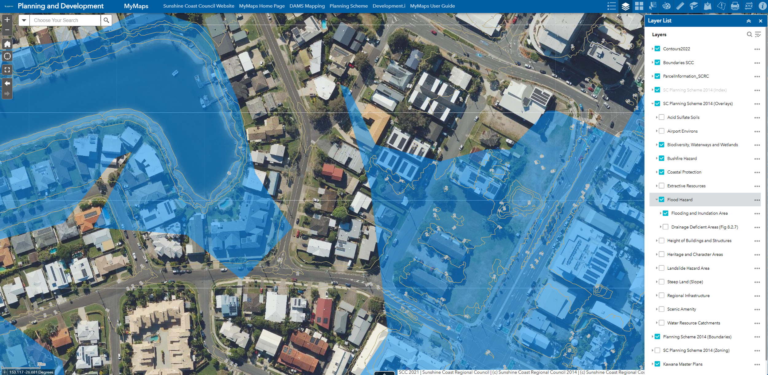
Sunshine Coast Council Planning and Development Map (Interactive Mapping System)
Sunshine Coast Council Development.i Site Report
Sunshine Coast Council provides property flood reports including the following:
Mapping and overview for all applicable planning scheme overlays
Flood-related overlays and information:
Flooding and Inundation Area
Defined Event Flood Hazard Area
Flood Risk categories
These site reports do not provide flood data/information. A Flood Information Search report is required for such data/information and planning purposes (discussed further below).
Sunshine Coast Council MyMaps - Flood Mapping and Information
Sunshine Coast Council provides additional flood mapping, including the following:
Utilities and infrastructure
Detailed flood information and sources
Historical flood information
Storm tide extents and more
The Flood Mapping and Information map is best used to identify the various sources and likelihood of flooding. This map is best used by advanced users for a better understanding of the flooding characteristics.
Steps to Follow
The following steps will assist you in identifying historical flooding affecting your property:
Go to Sunshine Coast Council’s Development.i Site Report page
Search for your property address
Click ‘View Report’
A summary of the overlays will appear on your screen
The screenshot below shows Sunshine Coast Council’s Development.i Site Report page.
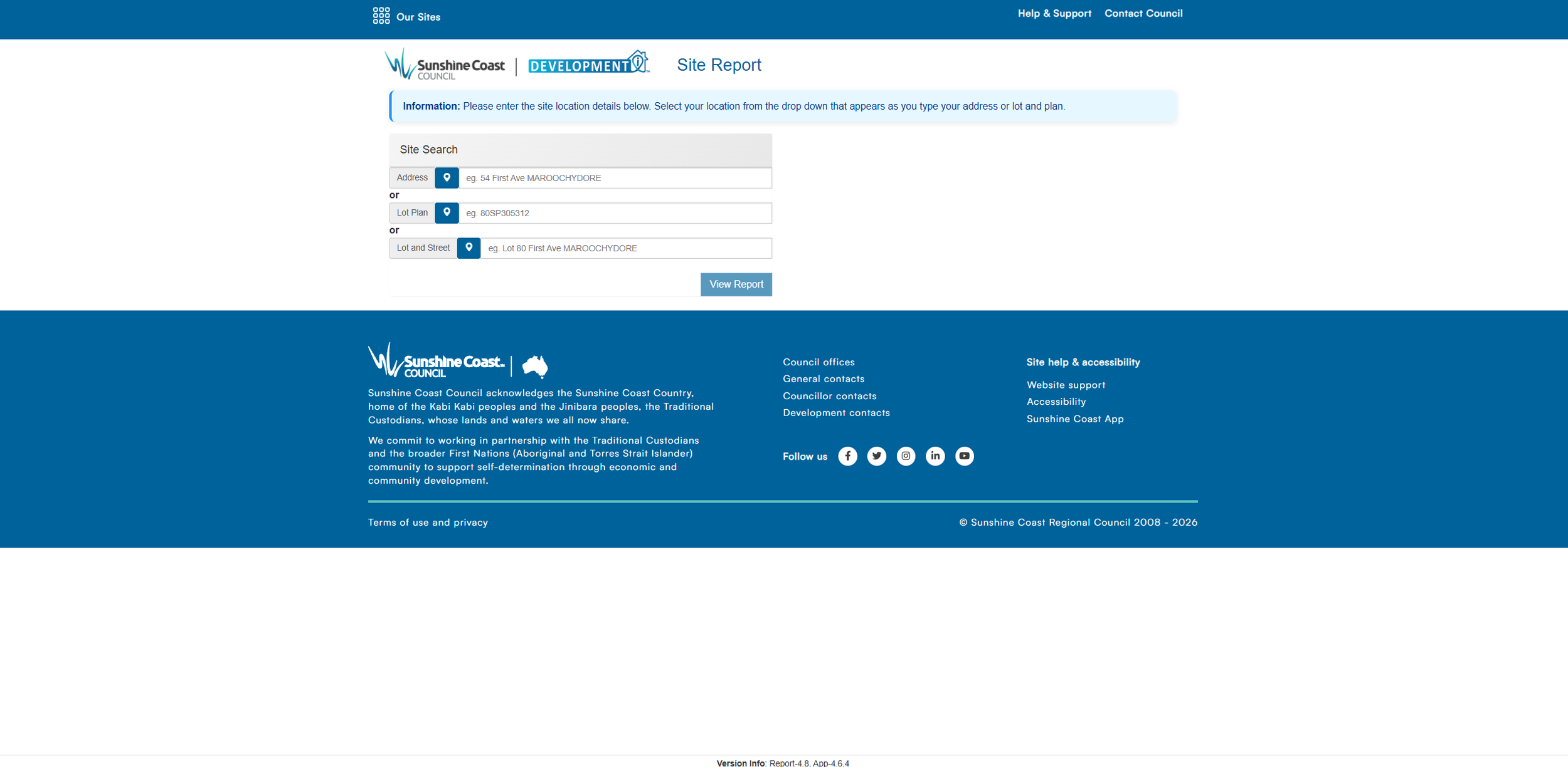
Sunshine Coast Council Development.i Site Report
Steps to Follow
The following steps will assist you in identifying the flood overlays affecting your property:
Go to the Sunshine Coast Council’s Flood Mapping and Information map
Search for your property address
Click ‘Layer List’ (left side of the website)
Filter through the layers to your liking
The screenshot below shows Sunshine Coast Council’s Flood Mapping and Information map.
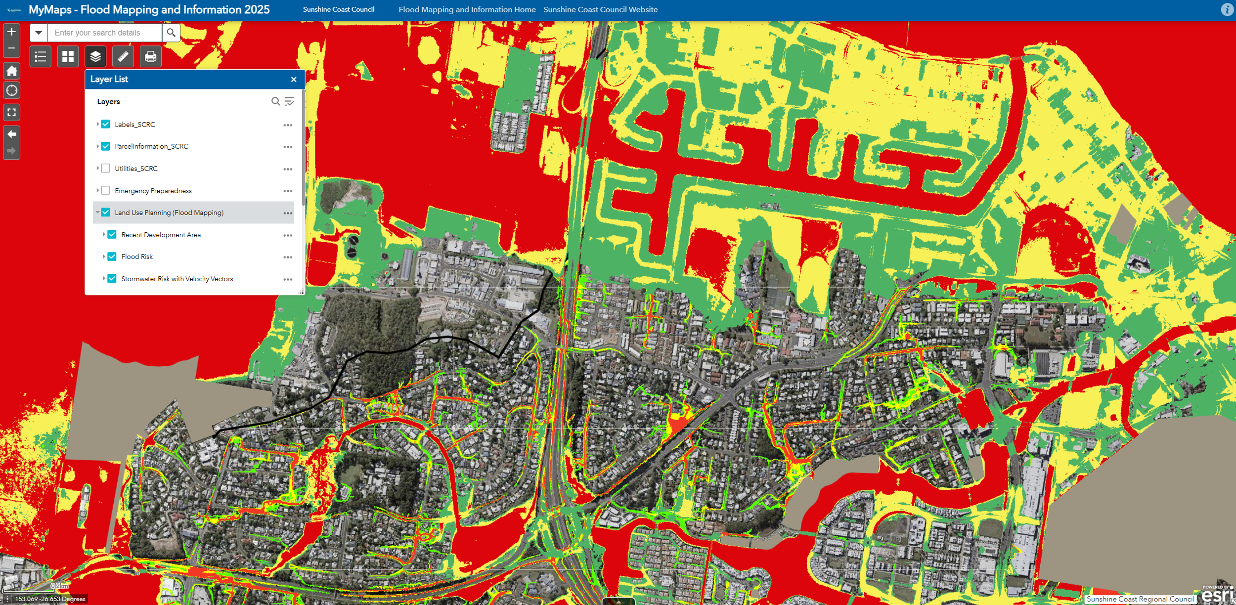
Sunshine Coast Council MyMaps - Flooding Mapping and Information
To view past and current applications in Sunshine Coast Council, visit the Development.ipage.
A Flood Information Search report can be purchased from Sunshine Coast Council by filling out a Flooding Search Application. The Flood Information Search report provides:
Ground level estimates
Applicable flood overlays
Flood levels, velocities, depths and hazards
Sources of flooding/inundation
Freeboard and flood immunity levels
Types of Assessments We Provide
These assessments are required by Sunshine Coast Council to ensure that adverse flood impacts are not created which may negatively affect neighbouring properties, the surrounding area and more.
During this assessment, the construction type and location is usually determined. This may involve altering the surface levels on your property, constructing on a suspended slab or creating flood channels/paths.
Flood Immunity Assessments:
Sunshine Coast Council requires various types of development to meet various flood immunity requirements so that floor levels are safe during overland flow and flood events.
This usually involves habitable floor levels, non-habitable floor levels, servicing levels and the ability for site occupants to traverse the site without being exposed to flood hazard.
Flood Risk Assessments:
When flooding may impact upon the ability for site occupants to traverse or evacuate a site, flood risk and flood emergency matters are to be addressed.
This usually involves evacuations plans, understanding of flood warning times, flood recovery considerations and more.
Overland flows paths are common throughout Sunshine Coast Council due to the various elevation changes in topography. Sunshine Coast Council does not typically provide flood data for overland flow paths. As such, it is important that overland flow assessments are undertaken through our TUFLOW hydraulic models to determine their characteristics and impact upon your property and future development.
At Flood Smart Engineering, we utilise TUFLOW hydraulic models to produce flood levels, velocities, hazards and extents for inundation sources such as overland flow. These models provide site-specific results so that we can focus on increasing development opportunity for your property and gaining council approval through the building application (BA) and development application (DA) phases.
Our experience in Sunshine Coast Council
Over the years we have worked on a large number and variety of projects in the Sunshine Coast region. The most common development applications we assist with are:
Residential developments and subdivisions
Knockdown-rebuilds and house raises
Commercial developments
Tourism and accommodation developments
Community infrastructure
Our local knowledge and expertise has contributed to our understanding of flooding characteristics throughout Sunshine Coast Council, including flooding associated with the Maroochy River, Mooloolah River, Pumicestone Passage, Coochin Creek, Currimundi Creek and surrounding waterways.
Sunshine Coast Suburbs We Commonly Service
At Flood Smart Engineering, we regularly work in the growth areas of Ipswich such as Maroochydore, Aura, Sippy Downs, Buderim, Birtinya and more.
FAQs
Do I need a flood assessment for my property?
1
If you are located in a flood overlay, you will most likely require a flood assessment to be undertaken. Flooding can be a complex issue and requires a keen eye to identify development opportunity. Please contact us and we can assist you with your property.
What is a Flood Information Search report?
2
The Flood Information Search report identifies the flood overlays and flood levels affecting your property. Please note that these reports are more specific to river and creek flooding sources.
Can I build in a flood overlay?
3
Flood overlays can be built in as long as compliance with Sunshine Coast Council’s Planning Scheme is achieved. Some properties have more development potential than others.
What experience do you have inSunshine Coast Council?
4
We are involved in a significant number of Sunshine Coast projects which has contributed to our local knowledge. The developments we work on range from rural toursim to commercial facilities.
Flood report costs vary depending upon the flooding type and complexity. Please contact us and we can prepare a formal proposal for your consideration.
A flood report is usually required for a building application (BA) or development application (DA) in Sunshine Coast Council. It is best to engage us as early as possible as the flooding component for a development can be crucial in determining engineering design.
How much does a flood report cost?
5
When do I need a flood report?
6
Sunshine Coast Council requires developments to meet flood immunity requirements. To be flood immune is to be free of/not affected by flooding for a given design flood event. The requirements generally include freeboard (an additional margin/height above the applicable flood level) to ensure adequate safety and consideration to design components.
What is flood immunity?
7
View the other councils we regularly work in.
Brisbane Logan Gold Coast Ipswich Moreton Bay Sunshine Coast Lockyer Valley