

Expert Hydraulic Modelling Services
Flood Smart Engineering provides hydraulic modelling services throughout South East Queensland, supporting flood assessments, overland flow assessments, development applications and building applications.
What is Hydraulic Modelling?
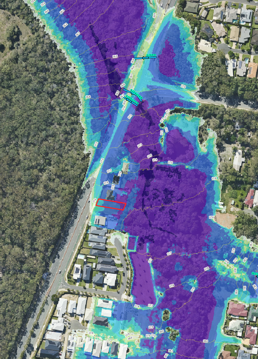
Hydraulic modelling uses advanced computer software to simulate how water moves across a site during flood and storm events. By assessing flood levels, depths, velocities, hazards and overland flow paths, hydraulic modelling helps identify development constraints, support council approvals and inform engineering design.
The Applications of Hydraulic Modelling
Hydraulic modelling is commonly used to support the following development and approval requirements:
Flood Impact Assessments to determine whether a proposed development will adversely affect neighbouring properties or surrounding flood behaviour.
Flood Immunity Assessments to establish minimum floor levels and demonstrate compliance with council flood planning requirements.
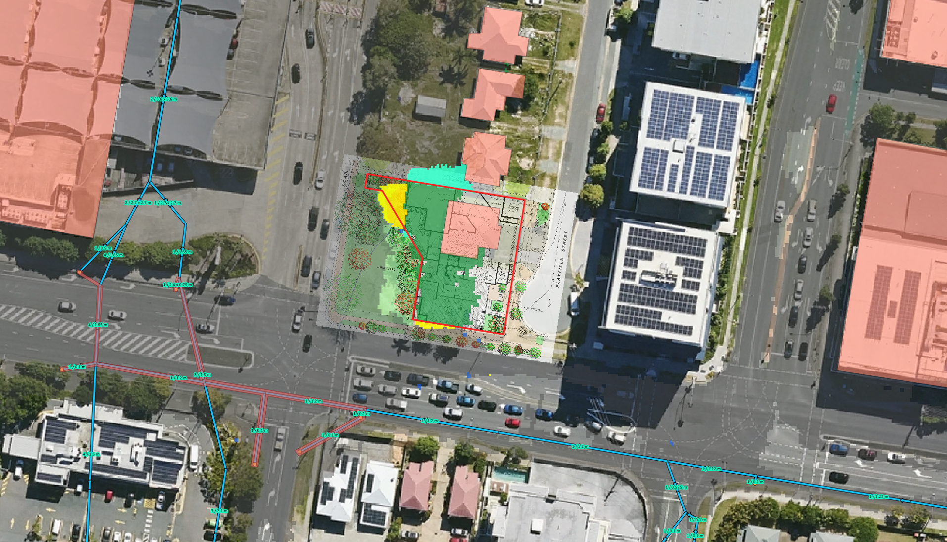
Overland Flow Assessments to determine flood levels, depths, velocities and hazards where council flood information is unavailable.
Development Applications (DA) requiring flood-related assessment against council planning schemes and flood overlay codes.
Building Applications (BA) where flood levels, flood immunity or overland flow conditions must be assessed prior to construction.
Subdivision, Commercial and Industrial Developments requiring detailed flood modelling to support engineering design and council approval.
Stormwater and Flood Management Design including the assessment of drainage systems, detention basins and flood mitigation measures.
TUFLOW Hydraulic Modelling
Flood Smart Engineering utilises TUFLOW hydraulic modelling software to simulate flood behaviour and overland flow characteristics for a wide range of developments throughout South East Queensland. TUFLOW is one of Australia's leading hydraulic modelling platforms and is widely accepted by councils, government authorities and engineering consultants for flood-related assessments.
Hydraulic modelling allows us to simulate how water moves across a site during flood and storm events, providing detailed information that is often unavailable through council flood mapping or property reports. This information can be critical in understanding development constraints and identifying practical engineering solutions.
Using TUFLOW hydraulic models, we can assess:
Flood levels
Flood depths
Flow velocities
Flood hazards
Overland flow paths
Flood extents
Flood impacts on neighbouring properties
Flood immunity requirements
These site-specific results are commonly used to support Flood Impact Assessments, Flood Immunity Assessments, Overland Flow Assessments, Development Applications (DA) and Building Applications (BA).
Our hydraulic models can be developed using a range of available information including survey data, council flood studies, terrain models, stormwater infrastructure information and site-specific design details. The modelling process allows multiple flood scenarios and development options to be assessed, helping to optimise project outcomes while maintaining compliance with council planning requirements.
Whether assessing a house raise, subdivision, commercial development, industrial facility or large-scale residential estate, TUFLOW hydraulic modelling provides the detailed flood information required to support engineering design and council approval.
Hydraulic Modelling Across South East Queensland
Flood Smart Engineering provides hydraulic modelling services throughout Brisbane, Logan, Gold Coast, Ipswich, Moreton Bay and Sunshine Coast. Our experience across multiple council areas, including Brisbane City Council, Logan City Council, City of Gold Coast, Ipswich City Council, Moreton Bay City Council and Sunshine Coast Council, allows us to understand local flood mapping, planning scheme requirements and flood-related development constraints.
Learn more about flood assessments, flood immunity requirements and hydraulic modelling within your local council area:

The Benefits of Hydraulic Modelling
Hydraulic modelling provides detailed insight into how flooding and overland flow may affect a site, allowing informed decisions to be made during the planning, design and approval stages of a development.
Key benefits include:
Determine Site-Specific Flood Levels
Hydraulic models can accurately predict flood levels, depths and flow paths across a site, providing critical information for development planning and design.
Support Council Approvals
Hydraulic modelling is commonly used to support Development Applications (DA), Building Applications (BA), Flood Impact Assessments and Flood Immunity Assessments.
Identify Development Constraints Early
Understanding flood behaviour early in the project helps identify potential constraints, reducing redesign costs and improving development feasibility.
Assess Flood Impacts
Hydraulic models can determine whether a proposed development may adversely affect neighbouring properties or surrounding flood behaviour.
Demonstrate Flood Immunity
Site-specific modelling can establish minimum floor levels and demonstrate compliance with council flood planning requirements.
Improve Development Opportunities
Detailed hydraulic modelling can identify practical engineering solutions that maximise site utilisation while effectively managing flood risk.
Frequently Asked Questions
-
Hydraulic modelling uses advanced computer software to simulate how water moves across a site during flood and storm events. The modelling can determine flood levels, depths, velocities, hazards and overland flow paths to support engineering design, flood assessments and council approvals.
-
Hydraulic modelling is commonly required when flooding or overland flow may impact a proposed development. Councils often require hydraulic modelling to support Flood Impact Assessments, Flood Immunity Assessments, Overland Flow Assessments, Development Applications (DA) and Building Applications (BA).
-
TUFLOW is one of Australia's leading hydraulic modelling platforms and is widely accepted by councils and government authorities. TUFLOW models can simulate flood behaviour and overland flow characteristics to provide detailed information including flood levels, depths, velocities, hazards and flood extents.
-
Yes. Hydraulic modelling is one of the most effective ways to assess overland flow paths and determine flood levels, depths, velocities and hazards where council flood information is unavailable or limited. This is particularly common for residential and development sites throughout South East Queensland.
-
Hydrologic modelling estimates how much runoff is generated from rainfall across a catchment. Hydraulic modelling then uses that runoff to simulate how water flows through waterways, drainage systems and overland flow paths. Both are often used together during flood assessments and development projects.
-
The cost of hydraulic modelling depends on factors such as site size, flood complexity, available flood information and council requirements. We can review your project and provide a tailored proposal based on the specific assessment required.